
It’s not just you, the world’s most touristy places are more crowded than ever.
The number of people traveling internationally has grown steadily since the 1950s with a great spike in the last year as travel interests peak in a post-pandemic era. Intense airline competition, falling fares and increases in disposable incomes are just some of the key reasons why travel has boomed in the past few decades: pre-pandemic, the United Nations World Tourism Organization recorded around 1.5 billion annual international tourist arrivals globally. But where do 1.5 billion people go?
The problem is, not all destinations are created equal in the eyes of tourists. In recent years we have cultivated homogenous travel desires whereby, often, we’re all striving towards the same experiences. We collectively dream of seeing the Eiffel Tower in Paris (check), the Grand Canyon (check) or the Hong Kong skyline from Victoria Peak (check).
Traveling beyond the classic honeypot destinations is a terrific way to spread your money to corners of the globe where local people desperately need it. Seek out the places where tourists are few and far between and your visit has the potential to make a real difference to people’s lives, creating incomes and opportunities that can empower entire communities.
Get inspired to travel off the beaten path with these 10 select highlights from Lonely Planet’s new Offbeat book; certain to feed your wanderlust.
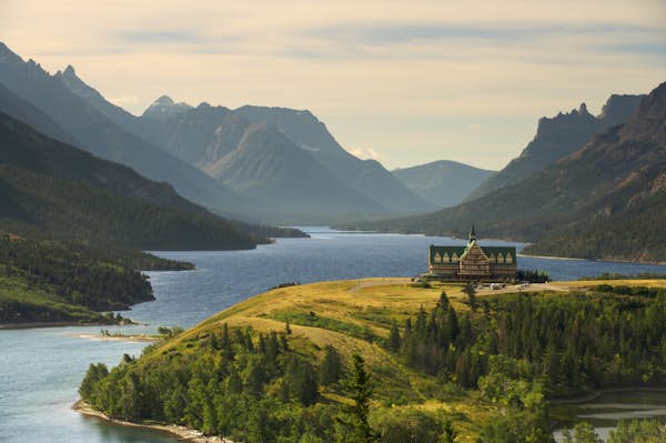
 A hike through Waterton National Park, Canada, one of the world’s first national parks © BGSmith / Shutterstock
Waterton Lakes National Park, Canada
Move over Banff and Glacier National Park — this Rocky Mountain bolthole has it all
In the Rocky Mountains between the big-ticket national parks of Glacier in the US and Banff in Canada, Waterton Lakes enjoys less celebrity and less traffic than its esteemed neighbors. Yet this spectacular pocket of the Rockies has international pedigree. Inaugurated in 1895 as one of the world’s first national parks, it has since been recognized by Unesco as a Biosphere Reserve and World Heritage Site. To add to its uniqueness, Waterton was conjoined with Glacier in 1932 to form America’s first International Peace Park, symbolizing the longstanding relationship between the two countries.
With its small town and handsome heritage hotel surrounded by chiseled mountains and a long navigable lake, Waterton is, in many ways, a microcosm of the larger Rocky Mountain parks to the north. But with all its sights stuffed into a compact 505 sq km (195 sq miles), its wilderness is refreshingly accessible. A rugged trail network emanates directly from Waterton’s town and more than 800 wildflower species dot its brawny backcountry, along with bears, cougars and ungulates.
Getting there: Waterton lies in Alberta’s southwestern corner, 270km (168 miles) south of Calgary. The one-road entrance into the park is in its northeastern corner, along Hwy 5. Car rental is available at Calgary International Airport. Alternatively, buses from Calgary and Fort Macleod will get you as far as Pincher Creek from where you can get a taxi the final 56km (35 miles) to Waterton town.
When to go: Jun-Sep; July and August offer the best weather and the most recreational opportunities, but also draw over half the annual visitors. Late spring is good for migratory birds and waterfalls. Early fall brings golden foliage, quiet trails and slightly cheaper accommodations.
Pro tip: Bring binoculars, a star chart and a warm blanket. Waterton Lakes is a Dark Sky Park with low light pollution, making it a wonderful place for stargazing. Head to Cameron Bay near the townsite on a cloudless summer night.
Canada’s best national parks
Discover Mexico away from the crowds
Monte Albán, Mexico
In the Oaxaca clouds lies a pre-Columbian city to rival Chichén Itzá
Though it bears a strong resemblance to Chichén Itzá, Mexico’s hilltop complex of Monte Albán pre-dates its Yucatán cousin by 750 years and receives just a fifth of the visitors. Set high above Oaxaca City, it was built by the Zapotecs around 500 BCE but eventually faded into slow obscurity until Leopoldo Batres began excavations in 1902, discovering a trove of important gold and striking pyramids. Alongside Chichén Itzá and the pre-Aztec Teotihuacan ruins outside Mexico City, Monte Albán is one of the most important pre-Columbian archaeological treasures of Mesoamerica.
The site’s strategic hilltop location puts it level with the clouds above Oaxaca’s Central Valleys, and as visitors stroll the grounds they can ponder the astronomical observations made from the site centuries ago. The Zapotec god of rain, Cocijo, was the main deity worshipped here, perhaps because the 400m (1312ft) elevation gives the perfect vantage on any storm clouds moving in. Come on a weekday and it can feel like a place where time has collapsed, far from the busy city below.
Getting there: Monte Albán is only 10km (6 miles) from Oaxaca International Airport, with direct flights from airports including Mexico City and Houston’s IAH. If you’re not pressed for time, it’s also easy to visit Oaxaca traveling by road from Mexico City.
When to go: Oct–Nov; October marks the start of the dry season, with ideal temperatures and clear skies. Time your trip right (in the lead-up to November 1-2), and you can view the local Day of the Dead altars in Oaxaca City during your stay.
Pro tip: Bring your own water – vendors may not be on hand and Monte Albán can be exposed to the sun (hats and sunscreen are a good idea as well).
Weird and wonderful hotels in Mexico for a unique vacation
Scout new ways to explore the planet’s wildest places with our weekly newsletter delivered to your inbox.
Ontario’s Black History Sites, Canada
The Underground Railroad led many formerly enslaved people to Canada.
In the 1800s, the network of safe houses across the US known as the Underground Railroad sheltered formerly enslaved people escaping to freedom. At least 30,000 of the Black Americans who followed this route settled in Canada, the majority in southwestern Ontario. Several sites across this region, west of Toronto and east of Detroit, enable visitors to learn more about the lives that these new Canadians established and the experiences of their descendants. While many locations across the US educate visitors about slavery and the struggles for civil rights, fewer travelers are aware of the way history played out in Canada.
The Ontario communities with key Black settlements include Windsor, Sandwich, Amherstburg, Dresden, Buxton and Chatham. The latter became a hub of intellectual life for Black Canadians known as ‘Black Mecca.’ The region’s attractions immerse visitors in railroad history, as you walk through 19th-century cabins and schoolrooms, examine shackles used on the enslaved or listen to (virtual) dogs barking as if you, too, were fleeing to freedom.
Getting there: Toronto Pearson International Airport is the main Canadian air gateway to Southwestern Ontario, but Detroit Metro Airport, across the border in the US, is also convenient. Via Rail trains travel between Toronto and Windsor, which makes a good starting point for explorations. Once you reach the region, public transit between communities is limited, so it’s easiest to explore by car.
When to go: May-early Oct; Summer has the warmest temperatures and everything is open; September and October are good months to visit if you want to combine your trip with autumn leaf-peeping and crisp days.
Pro tip: The Southwest Ontario Tourism Corporation’s website is a helpful resource for planning travel to the region.
16 hiking trails that showcase the very best of Canada
 A deserted building in Bodie State Park, part of California’s Lost Sierra © MARTAFR / Shutterstock
The Lost Sierra, California, USA
Where old gold-mining communities are reviving trails for adventurers.
Speeding downhill, your shoulders skimming the trunks of giant trees and the wheels of your bike bouncing over rocks and roots, it’s impossible to take your eyes off the trail ahead. But pull over occasionally to appreciate your surroundings among ponderosa pines or red fir trees, blue jays hopping from branch to branch, the only sound a river churning with snowmelt below. And there won’t be another soul in sight.
This is because you’re in the Lost Sierra, a triangle of 2591m (8500ft) peaks and glacial lakes roughly between the towns of Quincy, Graeagle and Downieville, a four-hour drive northeast from San Francisco. The closest comparison in California’s northern Sierra Nevada is Lake Tahoe nearby, but the Lost Sierra has none of that region’s visitor traffic. You don’t need to ride a bike to discover the Lost Sierra, either. The region is threaded with trails pioneered by gold miners 170 years ago but newly restored for hikers, horse riders and off-road motorcyclists by local groups determined to put the Lost Sierra back on the map.
Getting there: The closest airports are Reno-Tahoe, Sacramento, Oakland and San Francisco (the latter two most used by international visitors). From the west, Hwy 49 is the main (and twisty) route. From the north and east, you’ll likely use Hwy 89 or 70. There’s no practical way to explore the Lost Sierra without a vehicle of your own.
When to go: May-Oct; Higher trails may still be snow-bound in early June, although lower elevations are open all year. Ever-shorter winters bring snow, perfect for snowmobiles and snowshoeing. Fishing season is from April to November. Fire season gets longer each year.
Pro tip: There are no reasonable public transport options — you’ll need to have your own wheels or rent a vehicle. There are few gas stations here and even fewer electric vehicle charging points, so top up when you can.
Why you should drive California’s scenic Highway 395
PJ Sin Suela’s ULTIMATE Puerto Rico Tour: The BEST Beaches Food & Nightlife
Utuado, Puerto Rico
Taíno culture and river adventures in the mountains of Puerto Rico.
Tourists flock to Puerto Rico’s beaches but the island’s cultural heartbeat lies folded into the mountains of Utuado. Once home to the Taíno, the Indigenous people who inhabited much of the Caribbean before European contact, this lush area is a place for nature adventures and unique rentals. While only 1.5 hours from San Juan, tourists who base themselves here will find an emphasis on wellness and scenic tropical views reminiscent of Bali’s Ubud.
Utuado is one of the least populated areas of Puerto Rico. Peace and quiet reign – instead of the sounds of pumping nightlife, guests are serenaded by the dusk-induced song of coquís, small native tree frogs. Utuado feels secluded and mystical, providing a portal back in time through impeccably preserved petroglyphs at Caguana Indigenous Ceremonial Park, one of the most important archaeological sites in the Caribbean. To get there requires navigating winding, narrow roads but those who make the effort are rewarded with a connection to Puerto Rico’s ancestral pulse.
Getting there: Most visitors to Utuado fly into San Juan International Airport (SJU) but Rafael Hernandez Airport (BQN) in Aguadilla is another viable option. Both are less than 2 hours from Utuado, easily accessed by rental car. There is no public transportation to the area and shared car services can be hard to find.
When to go: Mid-Dec—Mar; Avoid hurricane season (June to November) and visit when the weather is cool and dry. This will allow for hiking and nature exploration with less chance of downpours, and maximize the odds of sunshine.
Pro tip: Special dietary requirements can be hard to cater for in Utuado because of its remoteness. If you need particular foods, consider bringing your own supplies – you can stock up at a supermarket like Freshmart in the metro area.
East End Puerto Rico, the perfect San Juan alternative
 Taking in the Milky Way at Balanced Rock in Big Bend National Park, Texas © Wisanu Boonrawd / Shutterstock
Big Bend National Park, Texas, USA
Blissful isolation keeps this Texan park from being overrun.
The mountains meet the desert in Big Bend, a vast national park tucked into a remote corner of west Texas. Set with steep-walled canyons, craggy peaks and a verdant river corridor carving through the scrubland, this expansive wilderness offers a wide range of adventures. You can spend your days hiking rugged trails, paddling along smooth rivers and soaking in natural hot springs, followed by an evening of stargazing in one of the world’s largest Dark Sky Parks. Big Bend is also an avian paradise, with over 450 bird species — the most of any national park in the US.
Make no mistake: Big Bend is remote. It’s more than three hours from the nearest airport, and by road, it’s a long way from anywhere (it’s at least an eight-hour drive from Dallas and Houston). Its isolation, however, has saved it from overdevelopment. The national park receives less than 10% of the visitors the Grand Canyon receives, and multiday excursions — like rafting on the Rio Grande — don’t require booking many months in advance.
Getting there: A car is essential to reach Big Bend. The nearest airports are in Midland, three hours north, and El Paso, five hours west. Rental cars are available at either airport. Main park roads are accessible to normal vehicles, but if you want to go deeper (and pitch a tent at remote backcountry road sites), you’ll need a 4WD.
When to go: Oct-Apr; Outside of the blazing summer months, you’ll find cooler temperatures as well as wildflowers in the spring (March through April). Winter is mild, though light snow is a possibility, and park trails are empty.
Pro tip: The Chisos Basin is a key gateway, with a visitor center, campground and trailheads (including access to Emory Peak). The Chisos Mountains Lodge, the park’s only non-camping accommodation, is also here.
The 6 most unmissable road trips in Texas
Buffalo, New York, USA
New York City’s little brother is a model of revival and resilience.
Thanks to its location on Lake Erie, Buffalo boomed in the early 1900s. Industries like steel manufacturing and car production thrived, and it was a major hub for transporting agricultural products from the Midwest. With power on tap from nearby Niagara Falls, it was the first American city to have electric streetlights. Talented architects were commissioned to design buildings and landscape the city’s parks, including Louis Sullivan, HH Richardson and Frederick Law Olmsted. Industrial collapse across the rust belt in the late 20th century left Buffalo a shadow of its former self, but in the last decade, revival has been in the air.
New York State’s second-largest city has been restoring its architectural gems, turning them into classy hotels and restaurants and incorporating them into public spaces. View impressive early career works by Frank Lloyd Wright, sip your way through a burgeoning craft beer scene and check out the redeveloped waterfront districts. This is a city that can hold its own against New York and Chicago, but which receives a fraction of their visitor numbers.
Getting there: Amtrak trains run to Buffalo’s downtown Exchange Street Station from New York City (8hr 30min), Niagara Falls (1r), Albany (5hr) and Toronto (4hr 30min). All services also stop at Buffalo-Depew Station, 13km (8 miles) east of the city center, which links in with trains from Chicago (10hr 30min). Alternatively, fly to Buffalo Niagara International Airport.
When to go: May–Aug; Summertime is the city’s high season, but the weather can’t be beat: average highs are in the mid to upper 20s°C (upper 70s°F to low 80s°F).
Pro tip: In downtown Buffalo, Metro Rail trains are free to ride for the stops between the Theater District and Harborcenter along Main St.
New York’s best road trips
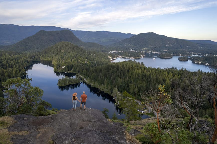 Pender Hill on the Sunshine Coast of British Columbia © stockstudioX / Getty
Sunshine Coast Trail, Canada
An epic adventure traveling hut-to-hut across British Columbia.
Canada’s longest backcountry hut-to-hut hiking route travels through the forests and mountains of coastal British Columbia in the region known as the Sunshine Coast. Yes, it can be sunny as you traverse this 180km (112 mile) route above the Pacific Ocean, particularly during the summer months, but you’re trekking in a temperate coastal rainforest, too. You’ll cross mossy bridges, shade yourself among old-growth firs and cedars, and—if you’re lucky—spot bald eagles soaring above the treetops as you hike.
There are 14 rustic huts in total – all free to use. Versatility is part of the beauty of this trail: those who don’t want to tackle the entire route, which takes
most experienced hikers 10 to 12 days, can day-hike sections, plan a shorter multiple-day backpacking trip, or organize an inn-to-inn adventure that combines hiking with craft beer tasting, canoeing and small-town exploring. Midway up the coast, the town of Powell River is a good base for tackling the trail in smaller segments.
Getting there: Vancouver is the international gateway. BC Ferries operates car ferry services from Horseshoe Bay, northwest of downtown Vancouver, to Langdale at the Sunshine Coast’s southern end. From Langdale, it’s an 80km (50 mile) drive north to Earls Cove, where you catch a second ferry to Saltery Bay, on the Upper Sunshine Coast, where the Sunshine Coast Trail begins.
When to go: Jun-Sep; The driest months on the Sunshine Coast are during the summer and early fall; October to April are particularly rainy throughout coastal British Columbia. Snow can linger into May at higher elevations.
Pro tip: Black bears live on the Sunshine Coast. Make noise as you hike to avoid surprising them and secure your food out of reach overnight.
16 hiking trails that showcase the very best of Canada
Milwaukee, Wisconsin, USA
The blue-collar brewski city with enough guts to rival nearby Chicago.
Milwaukee gets overlooked, standing as it does in Chicago’s shadow, and that’s a shame. Because like its big-city sibling, Milwaukee also flaunts a top-tier art museum, buzzing beer scene and beaches aplenty set against a Lake Michigan backdrop, but with only half the number of visitors partaking in the bounty. Those who make the trip 145km (90 miles) north are rewarded with a city that’s more relaxed, compact and inexpensive. Plus Milwaukee has several peculiar attractions you won’t find anywhere else, like the Bobblehead Museum, where more than 6500 dolls’ noggins bounce, and the American Geographical Society Library, filled with old maps, globes and Captain Cook’s hand-drawn charts.
Milwaukee developed its singular personality early on. Germans settled the city in the 1840s and many started breweries. By the 1880s Pabst, Schlitz, Blatz, Miller and 80 other breweries made suds here, and Milwaukee became known as the ‘nation’s watering hole.’ These days, Miller and a slew of microbreweries carry on the legacy.
Getting there: Getting to Milwaukee is a cinch, thanks to frequent train and bus services from Chicago right into downtown’s core. Milwaukee’s mid-sized airport has direct flights to 40 US cities. International flights typically go through Chicago.
When to go: Apr–May & Sep–Nov; Summer (June through August) is warm and festival laden, though it’s also the busiest time to visit. Spring and fall have fair weather and plenty of outdoor action, but with fewer crowds.
Pro tip: Stay over on a Friday evening so you can experience the traditional fish fry, a communal meal of beer-battered cod and coleslaw, when locals gather and mark the workweek’s end.
10 must-do things on your trip to Milwaukee
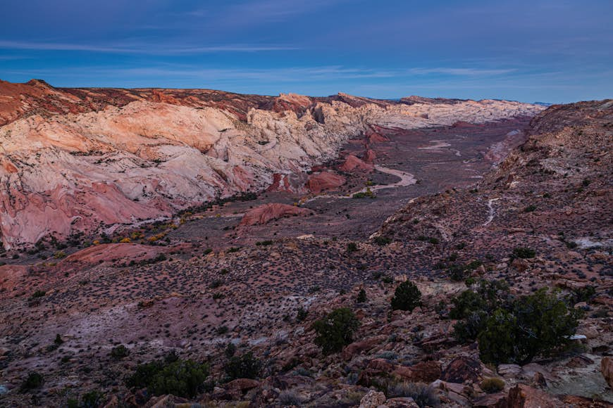 Waterpocket Fold from Halls Creek Overlook in Capitol Reef National Park © ShuPhotography / Shutterstock
Waterpocket Fold, Capitol Reef National Park, Utah, USA
Utah’s Grand Canyon has bags of drama but none of the tourists.
If you’re fantasizing about the kind of big deserts, red-rock mesas, searing blue skies and blazing-fire sunsets that only America’s wild, wild west can deliver, you’ve probably got the Grand Canyon in mind. It’s astonishing, no question, but it has also succumbed to the Unesco touch – popular trails, viewpoints and campgrounds get swamped in peak summer. Whereas a giant 563km (350 mile) leap north brings you to the delightfully under-the-radar Capitol Reef National Park, which receives just a trickle of the visitors, yet has an equally staggering geological marvel up its sleeve.
Out on its lonesome in Utah’s red rock country, Capitol Reef is remote enough to remain peaceful even during peak season. The park is a geologist’s dream, centering on the Waterpocket Fold, a near-160km (100 mile) wrinkle on the earth formed by the same forces that lifted the Colorado Plateau 65 million years ago. As the land buckled, it gave rise to a rocky spine of canyons, bridges, white-tipped domes, rust-red cliffs, fossils and skinny slot canyons, whittled into form over many millennia.
Getting there: You’re going to need your own wheels – and make it a 4WD if you plan on exploring the park’s remotest reaches. The closest international airport is Salt Lake City, 370km (230 miles) north. Alternatively, fly to Las Vegas, 547km (340 miles) southwest.
When to go: Mar–early Oct; Spring brings mild days perfect for hiking and orchards in full bloom; fall is just as glorious (bring layers for chilly nights in both seasons). Days are hot and arid in summer.
Pro tip: Book months ahead if you want to camp as demand is high, especially at the well-equipped Fruita Campground (open March to October). Otherwise, you’ll find a sprinkling of rustic lodges and rental cabins in Torrey.
The 8 best road trips in Utah
9 national parks you’ve never heard of