

Italy’s beaches and art-rammed cities often steal the limelight, but – trust us – it isn’t until you strike out into the wild mountains and trek along vertiginous coastlines that you can even come close to understanding how ravishing this country really is.
From the cliff-hanging trails of Amalfi to the colossal granite spires of the Dolomites, volcano climbs in Sicily to hikes deep into the heart of the flower-freckled Apennines – Italy is a boot made for walking. Here are eight of the country’s best hikes, with info on how to tackle them.
What you need to know about hiking in Italy
The best seasons for hiking in Italy are spring and early autumn – avoiding the scorching heat of mid-summer – though the window is shorter in the Alps and Dolomites (late June through September). Bear in mind that most Italians holiday in August, so trails are at their most crowded, and rifugi (mountain huts) in national parks are usually rammed; you’ll need to book your bed well in advance. Wild camping is a gray area – prohibited in theory but sometimes tolerated in practice, providing you avoid tourist hotspots, beaches and protected areas like nature reserves. If you do, go remote, arrive at dusk and leave by dawn.
Most local and regional tourist office websites can give you the inside scoop on walking in their area. The Italian Parks organization lists walking trails through each of the country’s 25 national parks. Tabacco produces a decent range of topographic 1:25,000 hiking maps and apps.
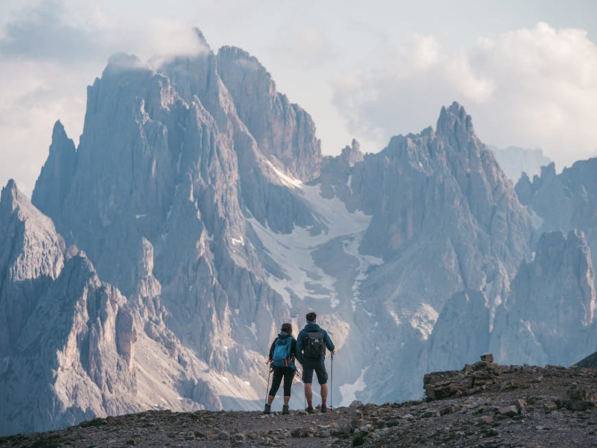
Get trusted guidance to the world’s most breathtaking experiences delivered to your inbox weekly with our email newsletter.  Reach heights of up to 4061m on the Sella-Herbetet Traverse © ueuaphoto / Shutterstock
Sella-Herbetet Traverse, Gran Paradiso, Piedmont
Best Alpine traverse
20.5km (13 miles) round trip, 9½–10 hours, demanding
If you’re into the Alps in a big way and crave a challenge, the Parco Nazionale del Gran Paradiso in the Graian Alps is a feast. Snug against the French border in the country’s northwest, this is a mind-blowing wilderness of piercing blue lakes, deep forests, rushing rivers and some of Italy’s highest, gnarliest mountains, topping out at its eponymous 4061m peak.
Starting in Valnontey, this classic one-day loop trail takes you right to its heart. From the town bridge in Valnontey, the Alta Via 2 leads along an old mule trail up to 2588m Rifugio Sella, a former hunting lodge of King Vittorio Emanuele II. Between here and Casolari dell’Herbetet (a park ranger’s base to the south), things get more exposed, with a traverse where you can cling on to a length of chain for protection.
The day’s ascent is 1180m and – oh joy! – the trip is virtually downhill all the way back to the village from the casolari. The views across the valley will make you gasp out loud: spiky peaks, small glaciers glinting on the eastern skyline, and the mighty Ghiacciaio Tribolazioni below Gran Paradiso itself. Herds of ibex and chamois graze peacefully on steep patches of grass, and you should also be able to hear and see marmots. Only tackle this one on a clear day; you’ll need to be surefooted and have a head for heights.
 Tre Cime de Lavaredo are three colossal rocky peaks in the Dolomites © SPavlo Glazkov / Shutterstock
Tre Cime di Lavaredo, Dolomites
Best Dolomite hike
9.5km (6 miles) round trip, 3-4 hours, moderate
Madre Natura sure was generous with Italy in the looks department, but she went the extra mile in the Dolomites, puckering up in the country’s northeast. The cloud-scraping limestone spires, buttresses and towers that punch high above meadows, lakes and spruce forests here offer some of Europe’s most compelling walking country. If you’re going to do just one day hike here, make it the Tre Cime di Lavaredo Circuit in the Parco Naturale Tre Cime.
Kicking off at Rifugio Auronzo, the trail weaves to Rifugio Lavaredo, then clambers up to Forcella di Lavaredo (2454m) with pop-up views of the Tre Cime – a trilogy of photogenic peaks shaped like bishops’ miters – slowly cracking open, before heading on to Rifugio Locatelli and back to Rifugio Auronzo. Get an early start to appreciate the trail at its silent best (it can get busy as the day goes on, especially during the summer) and avoid afternoon thunderstorms. Access the route via the toll road from Misurina (€30).
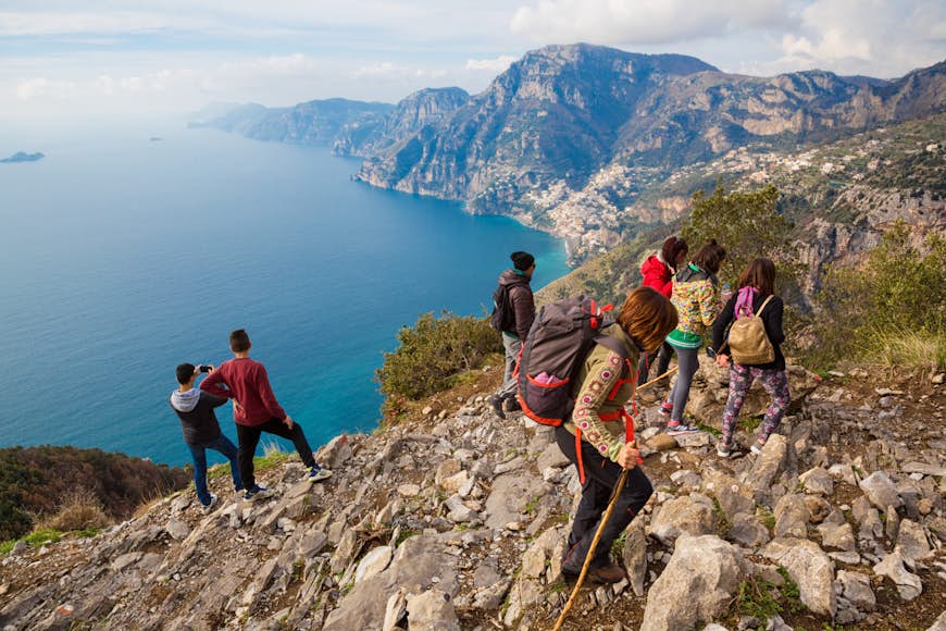 Try trekking the route from Agerola to Nocelle on the Amalfi coast, called “The Path of the Gods” © Francesca Sciarra / Shutterstock
Sentiero degli Dei, Amalfi Coast
Best sun-kissed stroll
8km (5 miles) one way, 4½ hours, easy-moderate
True to its name, the Sentiero degli Dei (Path of the Gods) presents a heavenly canvas of southern Italian landscapes, with sensational views of the rugged, densely wooded Lattari mountains that dive down to the glittering Mediterranean and candy-colored villages tumbling haphazardly down hillsides and distant glimpses of Capri. You can nail it in half a day, but with scenery like this, why on earth rush? Pack a picnic and grab a map of the walk from local tourist offices.
Following an elevated, often rocky mule trail linking postcard-perfect Positano to the ancient fishing village of Praiano, the path unzips some of the area’s least-developed countryside with minimal effort and is immediately spectacular. You’ll traipse past terraced hillsides, lemon orchards and fragrant macchia (scrub) of rosemary and holm oak. A flight of 1500 steps trips gleefully down to Arienzo, where you can pause for a cooling dip, seafood lunch and cocktail at the beach club. The sunsets here are something else.
Corno Grande, Abruzzo
Best mountain climb
9km (5.6 miles) round trip, 5-7 hours, moderate (normal route), demanding (direct route)
Presiding over the jagged rockscapes of the Parco Nazionale del Gran Sasso e Monti della Laga (one of Italy’s largest national parks), 2192m Corno Grande (“Big Horn”) is the highest peak in the Apennines. Its distinctive craggy profile etches the horizon and is visible all over Abruzzo, right in the heart of Italy.
From the main car park at Campo Imperatore, hook onto the via normale (normal route); it’s a surprisingly straightforward climb along moraine-streaked slopes to the summit, with 782m of ascent and some easy scrambling on the final leg. At the top, you’ll be gripped by views of rippling mountains and the Adriatic, a distant glimmer on the horizon, as well as tantalizing glimpses of Europe’s southernmost glacier, the Calderone.
If you’re an experienced hiker up for more of a challenge, choose the alternative ascent that zigzags directly to the summit, a much tougher climb. In the quiet of the early morning or late afternoon, you might spot a nimble-footed chamois or a royal eagle wheeling overhead. The best window for this hike is from early June to late September when the mountain is free of snow.
 You’ll find some of the best views of the pastel towns decorating the cliffs of Cinque Terre from the Sentiero Azzurro © MStudioImages / Getty Images
Sentiero Azzurro, Cinque Terre
Best coastal ramble
8.5km (5.2 miles), 3-4 hours one way, easy-moderate
Yes, Cinque Terre really is as jaw-dropping as the photos you’ve seen. The five precariously perched fishing villages painted in ice-cream colors look as though they’ll topple off the cliffside with the merest puff of wind. The Sentiero Azzurro (Blue Trail, marked No. 2 on maps) used to string them all together, teetering past vines, olive groves, forests and terraced hillsides, hugging the contour of the coastline cliffs along the sapphire Ligurian Sea. However, due to landslides, some sections of the route are currently inaccessible and are being pieced back together. For the latest updates, visit the website, detailing which sections are open.
The route is best walked east to west, from Riomaggiore to Monterosso. However, the first section of the trail, Riomaggiore-Manarola, is likely closed until 2024, so you’ll need to start your hike at vine-wreathed Manarola, where houses cling to the sheer clifftops in a fresco painter’s palette of colors. You’ll also need to purchase a Cinque Terre Card (€7.50 for one day), which gives you access to the national park and use of its facilities.
Selvaggio Blu, Sardinia
Best hardcore multi-day trek
45km (28 miles) one way, 4-7 days, very demanding
If other hikes aren’t quite hitting the off-the-radar sweet spot, oh, intrepid one, this epic jaunt along Sardinia’s ragged east coast never fails. Often hailed as Italy’s toughest trek (and you’d better believe it), the Selvaggio Blu, or “Wild Blue,” throws you in at the adventure deep end. Threading its way along the Golfo di Orosei on Sardinia’s east coast, this is a never-to-be-forgotten, away-from-the-world hike that requires mountaineering experience. Signs and water are desperately lacking, trail finding is tricky (even with GPS), and the going can be grueling, with abseils of up to 45m and UIAA grade IV+ climbs.
But it’s worth it. Heading south to north from Pedra Longa to Cala Fuili, the multi-day hike wriggles along one of Italy’s wildest and most isolated coastlines, with deep gorges, impenetrable vegetation, cliffs dipping up to 800m and unrivaled views of the Mediterranean. Old shepherds’ and charcoal burners’ paths weave past silent coves and dramatic overhangs. By night, you’ll camp under the starriest of night skies at remote beaches and in caves. However, unless you are familiar with these parts, you will need a guide, such as mountaineering and climbing pro Corrado Conca.
 The climb to Stromboli volcano’s crater is a favorite among outdoor lovers in Sicily © Marco Crupi / Shutterstock
Stromboli, Aeolian Islands, Sicily
Best volcano ascent
7.8km (4.8 miles) round trip, 5-6 hours, moderate-demanding
There’s no better way to get a handle on the smoldering beauty of Sicily’s Aeolian Islands than by hoofing it up to Stromboli’s perfect pyramid of a volcano. Thrusting above the cobalt sea, it certainly has the wow factor. It’s not every day, after all, that you get to trek up to a permanently active cone. The most captivating of the Aeolian Islands, Stromboli is a whippersnapper in volcanic terms, only formed a mere 40,000 years ago. For nature lovers, the climb to its crater is one of Sicily’s not-to-be-missed experiences.
The hike is as diverse as it is exhilarating, with wild capers and Sicilian broom lining the trail. It gives adventurers incredible panoramas over Stromboli town, as well as starker, high-level elevation landscapes that contrast with dramatic sea views. Go at sunset to witness the crater’s fireworks at the 924m summit as day fades to night, then hike back down to town by flashlight in the darkness. Authorities strictly regulate access – you can walk freely to 400m, but you’ll need a guide (such as the knowledgeable guides at Magmatrek) to continue any higher. It’s also worth remembering that this is an active volcano – with a major eruption as recently as July 2019 – meaning this climb, though beautiful, comes with additional risk.
 Trekkers on Via Appia Antica will find numerous ancient Roman ruins still standing alongside the Roman Empire’s first highway © ValerioMei / Shutterstock
Via Appia Antica, Rome-Brindisi
Best historic hike
12.9km (8miles) one way, 2½-3 hours, easy-moderate
All roads lead to Rome on the Via Appia Antica (the Appian Way). The first mighty highway of the Roman Empire, it was built between 312 BC and 190 BC to link Rome to the port of Brindisi on the southern Adriatic coast, 300 miles distant. The arrow-straight path takes its name from the man who laid the first stone: Appius Claudius Caecus.
While much of it is off bounds and overgrown these days, this stretch gives you a tantalizing peek of what travel would have been like more than 2000 years ago, as you tread cobblestones polished smooth by millennia of cart wheels, horse hooves and hobnailed Roman caligae (heavy-soled military sandals) and leave the frenetic buzz of Rome behind to slip into peaceful, cypress tree-dotted countryside.
It’s wrong to assume that all of Rome’s cultural big hitters are all in the center. Strike out along this path, and you’ll be amazed by the monuments and milestones that confront you at every turn, fully immersing you in the city’s enthralling past: the romantic ruins of villas where Rome’s elite lived, catacombs, above-ground tombs and mausoleums.
This walk begins at the 5th-century Porta San Sebastiano, the largest of the gates in the Aurelian Walls, and ends at 2nd-century Villa dei Quintili, towering over green fields. En route, factor in stops at tiny Chiesa del Domine Quo Vadis, where St Peter encountered a vision of Jesus, the Catacombe di San Callisto, where 16 popes, dozens of martyrs and thousands upon thousands of Christians lie entombed, and Villa di Massenzio, the 4th-century palace of the emperor Maxentius, where you’ll find Rome’s best-preserved chariot racetrack, the Circo di Massenzio.