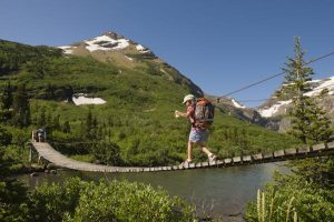
With landscapes that tumble from snow-dappled Andean peaks to paradisiacal white sand beaches, it should come as no surprise that Colombia packs a whole raft of hiking trails to explore.
Trekking can be a hot, humid affair in the lowlands and a lung-busting adventure in the mountainous national parks, but there’s no better way to explore this remarkable terrain than on a hike.
Following decades of conflict concentrated in rural areas, the demobilization of some key armed groups has paved the way for access to trails in some of Colombia’s once inaccessible remote outposts. While some trails are signposted, most are not, so hiking in Colombia safely often requires the assistance of a local guide, whose knowledge of the fragile ecosystems and local customs are invaluable.
Getting out onto the trails is a way of seeing Colombia in a new light. This isn’t just a place of vivacious cities and infectious rhythms, but also a country home to enchanting archaeological sites, rare endemic wildlife and dizzyingly high-altitude scenery.
Explore the planet’s most surprising adventures with our weekly newsletter delivered to your inbox.
1. Ciudad Perdida Trek
Best jungle hike
40km (24.8 miles) round trip, 5 days, moderate
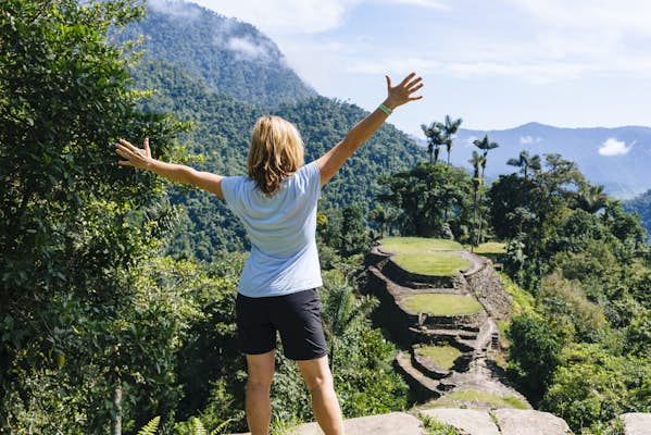
Hikers of all stripes gravitate to the Ciudad Perdida (Lost City) trek, Colombia’s most mystical trail. This epic route is the country’s answer to the Inca Trail, but where Peru’s legendary mountaintop fortress teems with tourists, the lost city hidden away in Colombia’s Sierra Nevada de Santa Marta mountain range sees very few visitors.
It helps that the former stronghold of the Tairona people can only be reached by a five-day trek, discouraging fair-weather hikers. And visitor numbers have yet to fully recover from pre-pandemic levels, making now an excellent time to take on the adventure. It’s a steep, sweaty and sometimes grueling slog through seemingly impenetrable jungle, although crystalline swimming holes and hammocks slung with mosquito nets make for welcome stops en-route.
Early on day four, a flight of 1200 stone steps delivers you to the silent grounds of this 32-hectare city, where tendrils of jungle still cling to the remarkably preserved remains of circular stone terraces, plazas and storehouses once used by a population of more than 4000 people.
You can only reach the Ciudad Perdida as part of an organized trek, so arrange your tour in Santa Marta. All trekking companies and guides are local, ensuring your money flows directly back into the communities you pass through along the way.
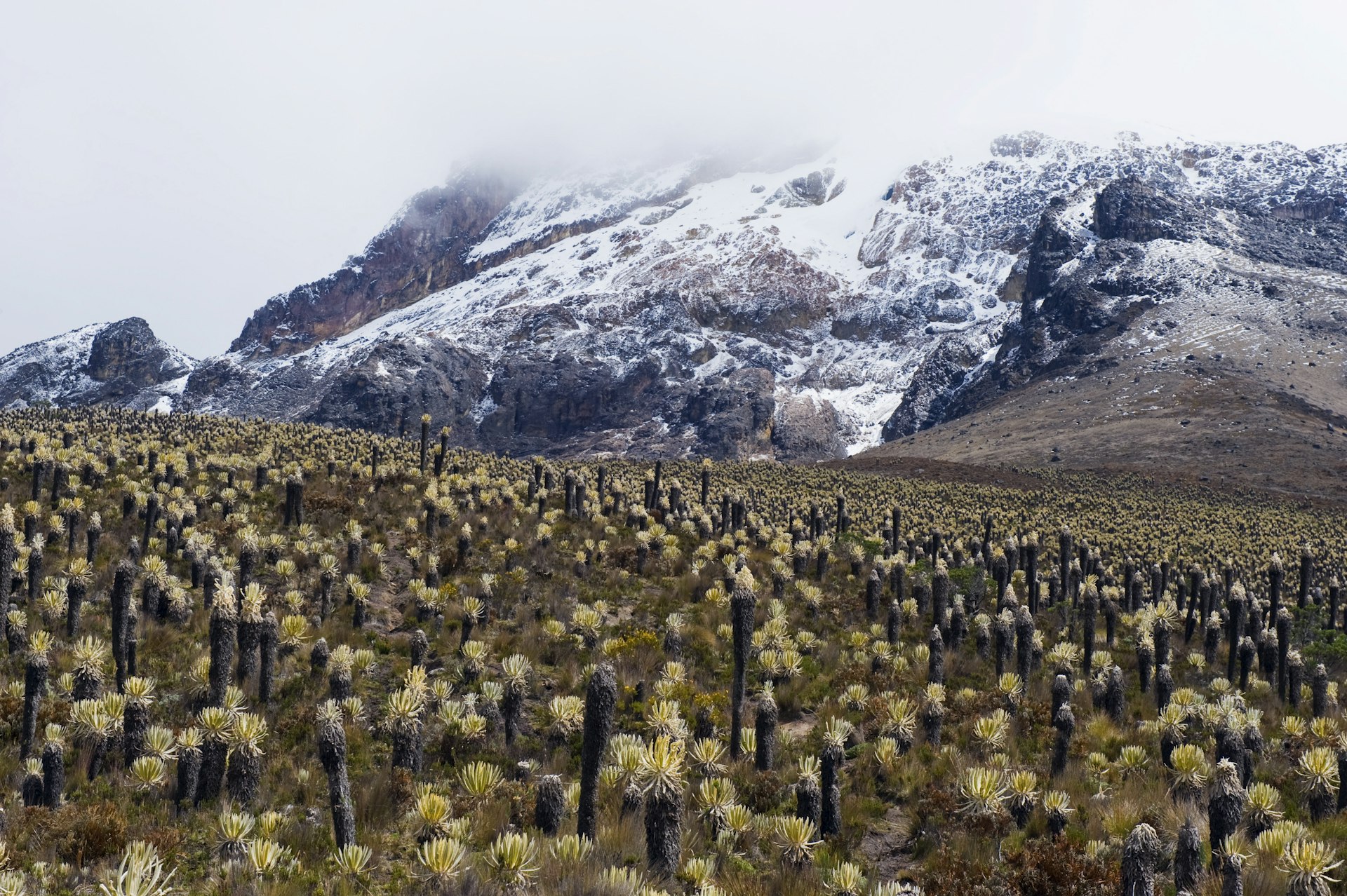 Spiky frailejone plants make stretches of the hike to Nevado del Tolima very slow going © Christian Kober / Getty Images
2. Nevado del Tolima summit
Best high-altitude hike
58.5km (36.3 miles) round trip, 4 days, challenging
Snowy peaks might be an unexpected sight in the tropics, but that’s what you’ll find in Parque Nacional Natural Los Nevados. A cluster of 5000m (16,400ft) volcanic peaks rising from the lush hillsides of Colombia’s main coffee region, the park attracts trekkers and mountaineers from around the world, keen to conquer its challenging high-altitude terrain.
At 5200m (17,060ft), Nevado del Tolima is the second tallest volcano here and the highest peak that visitors are permitted to climb. Following a series of accidents, access to the south face of the mountain is now restricted. The remaining approach to the summit is a challenging and technical ascent, covering 58.3km (36.3 miles) and only suitable for those with previous mountaineering experience. Ropes, ice axes, harnesses and crampons may be needed for higher sections.
Starting in the Valle Cocora, the hike climbs steeply through the park’s trademark landscape of Quindío wax palms before the scenery transitions into the uniquely Andean ecosystem known as paramo. This grassy shrubland is dotted with spiky, slow-growing frailejónplants, said to resemble the silhouette of a hooded monk.
Higher still, glassy lakes, glaciers and views of the perfectly conical crater of Tolima add to the sense of adventure as you struggle up to the summit. Having conquered Tolima, admire the views towards the gently smoking tip of highly active Volcán Ruiz, the park’s tallest peak, and soak up the majesty of the experience.
For a gentler introduction to the park, consider the three-day trek up to the snowline at around 4600m (15,091ft). You’ll miss the thrilling final ascent but will be spared the need to bring climbing ropes, ice axes and other technical gear. To avoid the heaviest rainfall, hike in January or February, but note that poor weather is a possibility year-round – trekking poles are highly recommended.
3. Cueva del Esplendor
Best waterfall hike
23km (14 miles) round trip, 7 hours, moderate
The town of Jardín near Medellín draws visitors with its picture-perfect streets painted in a riot of vibrant shades, but there’s more to do here than sip coffee in the shady plaza. For a more active day out, you’ll want to head out to the town’s most popular hiking destination – the cavern known as Cueva del Esplendor.
This long day hike begins on the western edge of Jardín and climbs into the patchwork of rolling hills and farmland that defines Colombia’s coffee-growing region in the Andean foothills. Muddy trails wind past rushing streams and creep through dense forest, so you’ll need sturdy hiking boots and some steady footwork. Eagle-eyed hikers may spot rare bird species such as the orange-breasted tanager finch flitting in the canopy above.
Once you arrive at the cavern, it immediately becomes clear why this fissure in the rock is known as the Cave of Splendor. As your eyes become accustomed to the darkness, you’ll be spellbound by the sight of a roaring blast of foaming water bursting from the roof into a pool below. The cave sits on private land, so you’re required to pay an entry fee, and a limited number of visitors are allowed in each day.
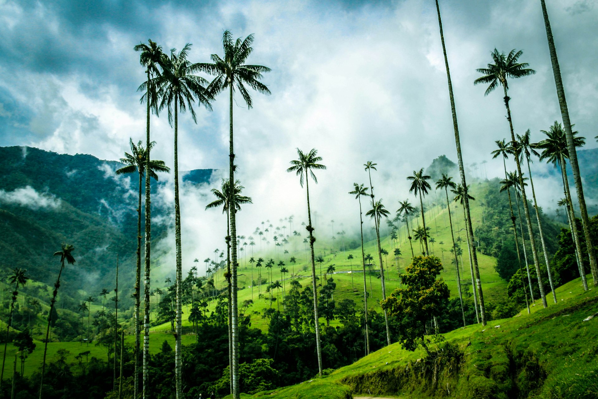 Wind your way through distinctive Quindío wax palms that tower over the Cocora Valley © Aileen Wolf / 500px
4. Cocora Valley Hike
Best hike for whimsical landscapes
15km (9 miles) round trip, 6 hours, moderate
Parque Nacional Natural Los Nevados might be dominated by its volcanic summits, but there’s plenty of less challenging terrain to engage hikers in the nature reserves just outside the park boundaries.
Reached by the iconic Willy Jeeps that rumble between Valle Cocora and the town of Salento, the region’s most acclaimed day hike clambers up onto hillsides that offer picture-perfect views over the whimsical Quindío wax palms, the national tree of Colombia, that line the valley floor.
Stop for a breather and a photo opportunity at the Reserva Natural Acaime La Casa de Los Colibríes (a hummingbird sanctuary), but save some space for shots of the palms themselves, which grow up to 60m (200ft) tall and end with a sparse cluster of leaves at their tops, like trees in a Dr Seuss book. Keep your eyes on the skies, too – the valley is an important habitat for the endangered yellow-eared parrot.
5. El Pulpito del Diablo Trail
Best hike for dramatic views
22.3km (13.8 miles) round trip, 12 hours, moderate
Packing in dozens of spectacular mountain peaks and a plethora of glassy, glacial lagoons, Parque Nacional Natural El Cocuy is the lost corner of Colombia. Here you’ll discover the country’s high-altitude landscapes at their finest – a remarkable contrast to the verdant rolling hills and tropical jungle that dominate much of the national terrain.
Situated in the far east of the country near the border with Venezuela, and more than 10 hours by road from Bogotá, this stunning national park is truly remote. Despite this, concerns over the environmental impact of tourism have led to the closure of many of the hiking trails. Luckily, one of the finest treks – the out-and-back hike to El Pulpito del Diablo – remains open, though all visitors must hike with a guide.
Hitting highs of 4765m (15,633ft), this hike requires a few days of acclimatization to ensure your lungs are adjusted to the elevation. Starting on the western side of the national park, the trail will lift you up to the edge of a gleaming glacier, with the dramatic El Pulpito del Diablo (Devil’s Pulpit) monolith rising above you as a fiercely vertical slab. Touching the glaciers in the park is not permitted, but you’ll reach the snowline as part of this trek, which offers glorious views back across the park and its barren landscapes of alpine tundra and electric blue moraine lakes.
 One of Colombia’s easiest short hikes is to follow the route of the Camino Real © mehdi33300 / Shutterstock
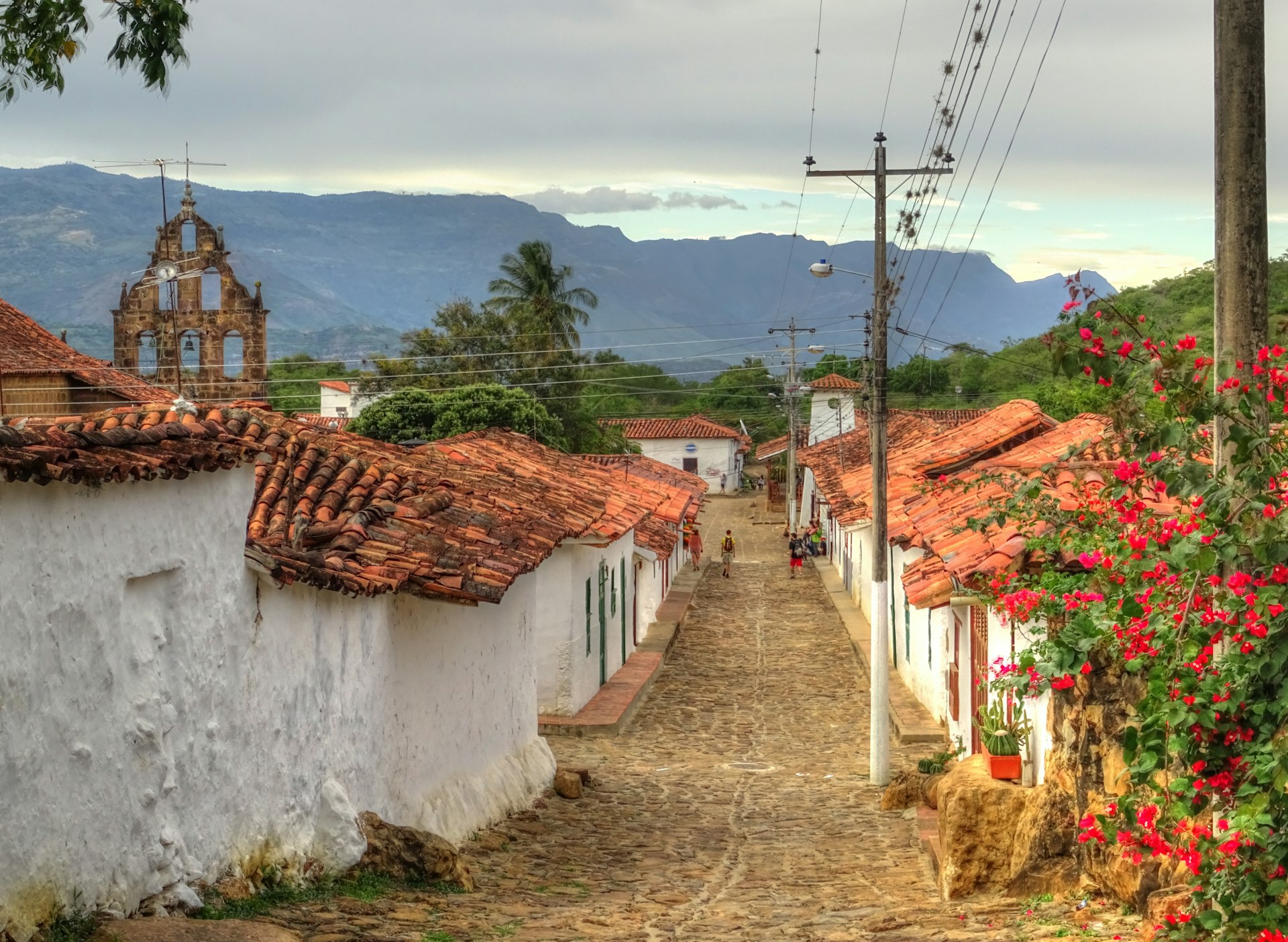
6. El Camino Real
Best easy hike
9km (5.6 miles) one way, 1 hour, easy
Lofty mountain adventures aren’t the only type of hiking in Colombia. Just a 30-minute drive from Colombia’s adventure capital, San Gil, and tucked into the heart of Santander department, the pretty town of Barichara is home to a stone-paved trail that descends through a scenic valley to the sleepy village of Guane.
Originally constructed by the indigenous people of this region, the Camino Real is a historic hiking route that has been traversed for centuries, and every step grants ever broader views over this cactus-filled valley and the folds of the mountains beyond.
Before you start walking, you’ll want to spend some time checking out the durable traditional whitewashed buildings of Barichara, many of which were built during the colonial period from compressed sand and clay. The trail starts on the outskirts of town and when you reach Guane, you can hop on a bus back to your starting point or head onwards to San Gil.
7. La Chorrera Waterfall
Best day hike from Bogotá
6.4km (4 miles) round trip, 3 hours, easy
One of the best hikes within striking distance of Bogotá, the route to La Chorrera Waterfall follows another stretch of the Camino Real, built during the period of Spanish colonization to provide a direct route linking Bogotá and the city of Villavicencio, some 100km (62 miles) south.
This ambling but easy to follow path is hemmed in by a dense sweep of cloud forest thick with bromeliads and the trills of birdsong. But the prize lies at its conclusion – at 590m (1935ft), La Chorrera is Colombia’s highest waterfall, with seven steps spilling furiously over a limestone escarpment veiled with moss and lichen, then crashing into a glassy pool.
While the trek isn’t particularly strenuous, you’ll need to spend a couple of days acclimatizing in Bogotá beforehand to prepare yourself for the altitude of over 2400m (7874ft). You should also pack a waterproof coat and be mentally prepared to get wet; the waterfall is often shrouded by clouds that dump bursts of rain onto the damp vegetation below.
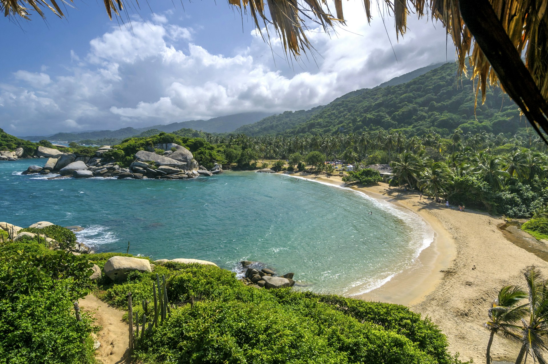 The beach at Cabo San Juan de Guía is the idyllic endpoint of the hike from Cañaveral © javarman3 / Getty Images
8. Cañaveral to El Cabo San Juan de Guía, Parque Nacional Natural Tayrona
Best beachside hike
8km (5 miles) one way, 2 hours, easy
The setting for some of Colombia’s most beautiful beaches, Parque Nacional Natural Tayrona is awash with unblemished white sands fringed by lush jungle and azure waters. While there are a handful of inland hikes within the park, the best hiking route here is the trip from Cañaveral (accessible by minivan from the park’s eastern entrance at El Zaíno) along the coast.
This path passes a string of picturesque tropical coves, following a mix of muddy and sandy trails and wooden boardwalks, to reach El Cabo San Juan de Guía, where two idyllic beaches with hammocks slung between palm trees offer you a place to rest overnight if you want to spread the hike over two days.
As you wander along the coast, keep your eyes peeled for chattering cotton-top tamarin monkeys – an introduced species that has thrived in these perfect conditions – as well as basilisk lizards that can dash across the surface of the water.
Because of incredibly strong rip currents, it’s not possible to swim at most of the beaches you pass on this hike, but you can take a refreshing dip in the sea when you arrive at your final destination.
9. Tierradentro Mountain Circuit
Best archaeological hike
12km (7.5 miles) ,8 hours, moderate
Explore underground tombs and fierce-looking stone statues on this challenging hike through the glorious green mountains of the Parque Arqueológico Tierradentro in the southern department of Cauca, which can be done without a guide at your own pace.
Before you begin, pop into the museum at the park entrance to get some background on the mysterious civilization that once inhabited these lands and left behind these intriguing glimpses of their culture.
The hike then climbs up to the most important ruins at Alto de Segovia, where you can descend spiral staircases into some of the tombs to check out the mesmerizing geometric wall paintings. Continuing on up into the mountains, the loop follows dirt paths and traffic-free country roads, calling at three more groups of tombs as well as a statuary on a plateau before winding its way back down to the park entrance once more.
Bring a flashlight as some of the more remote tombs have no lighting.